Command, Control, Communications, Computer and Intelligence (C4I)
"Easy Control, Effective Management, Total Command"
Baykar's Command, Control, Communication, Computer and Intelligence (C4I) technologies specially developed for unmanned aerial vehicles refer to the user interfaces engaged with the control of our aircraft. Our systems enable accurate analysis of every detail in critical tasks that require precision, simultaneously enabling information transfer for operational planning.
Bayraktar Ground Control Stations
Baykar’s unique ground control stations are designed to provide maximum control in even the riskiest weather conditions.
Our latest generation digital cockpit allows the user to effectively control the aircraft and its payload during any mission with uninterrupted communication.


Bayraktar Mini Ground Control Station
Bayraktar Gözcü 3 Mini UAV system, an essential tool in the arsenal of security forces, provides easy installation and easy flight in all weather conditions and is capable of landing safely in difficult terrain after the mission.
The Gözcu 3 is distinguished from other UAV systems most distinctly in its
- Ground control station that provides real-time monitoring and management,
- Strengthened enterprise-grade features that enable installation without being affected by weather conditions, and
- Ease of transportation with its lightweight conformation
AKINCI Ground Control Station
Designed by Baykar R&D engineers in accordance with military and ergonomic standards, the completely indigenously produced Akinci Ground Control Station (GCS) is of great importance for the management of UAVs in a multitude of environment conditions. Different GCS concept designs developed by Baykar offer solutions permitting a variety of missions to be carried out.
There are three different AKINCI GCS concept designs: Container, Trailer and Indoor. Trailer type shows great performance with its mobility in the field under harsh mission conditions. Indoor GCS provides multi-mission ability from the operations center.


Operations Center
Developed to strengthen network-centric warfare capacity, the operations center enables evaluation of critical data from multiple UAV operations and provides coordination between UAVs, enabling planning at a high-level.
Map and Navigation Module (CAS)
The Map and Navigation Module is a geographic information system that provides the user with the functions of flight mission planning, UAV location and terrain / topological displays, military symbol markings and location information search.
Features:
• Provides a 3D real world model.
• Displays 3D landform shapes.
• Provides 3D representation of UAV location information.
• UAV flight mission planning can be performed by the user.
• Provides the user with automatic guidance of the UAV.
• Map military symbol markings of Target, Zone (Friend, Enemy, No-Fly), Bookmark, etc.
• Performs line-of-sight analysis.
• Analysis of crash detection

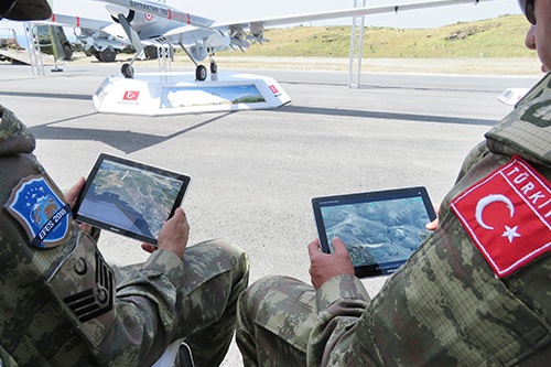
Image Transfer Center & "Raven" (Kuzgun) Application
The Image Transfer Center (GAM) enables an uninterrupted transfer of live images from UAVs to multiple users at the same time.
All images monitored by GAM are stored along with the date of operation, geographic location and notes attached by personnel.
The "Raven" (Kuzgun) application transfers images from UAVs to mobile devices of military personnel working in the operating region.
With this system that transmits using secure channels and works in integration with GAM, threats are identified in missions, and measures and attack decisions are taken faster and more safely.
MYGS Central Management Surveillance System
The Central UAV Management Surveillance System (MYGS) is a web-based mapping tool designed to display basic information about UAVs. Thanks to this system, air traffic control, mission planning, antenna planning and frequency planning can be performed easily. MYGS allows users to observe all flights in a summary format.
Position, attitude, remaining fuel, payload information, emergency alarms and connection information (Ground Control Station - GCS, Ground Data Terminal - GDT) of UAVs can be monitored through this system. In addition to this information, MYGS supports users with altitude tables, proximity alarms, flight codes and UAV tracks to keep the UAVs separate from each other. The status of the ground antennas and the interaction limits of these antennas can also be shown on the map.
